info@francescosways.com +39 0758241011
info@francescosways.com +39 0758241011


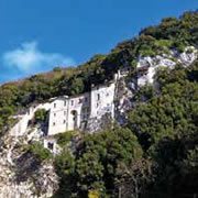
Leave the Franciscan sanctuary, perched on the rocky mountain slope, behind you as you begin to climb along the road. Pass the Fonte Lupetta (Km 2), “empress of mineral waters”, according to the sign, arriving in Greccio’s piazza (km 2.15), lined with cafès and restaurants. Skirt the historic center of town to the left, and continue along the tree-lined avenue, SC Greccio, ignoring the side streets. Enjoy the wonderful view of the Terminillo mountain peaks and the Valle Santa, dotted with Franciscan sanctuaries. Pass a large shrine dedicated to the Virgin Mary. At the crossroads (km 3), the route descends to the left along a tractor track through thick vegetation, alternating stretches of dirt with asphalt. Through the dense woods, the Abbazia di San Pastore (km 4) appears, topped by its magnificent belltower. The trail offers a lovely view over the plain, covered in tilled fields lined with irrigation canals. You’ll need to pay close attention for the wooden “Cammino di Francesco” signage, sometimes camouflaged among the trees. Continue through the woods circling the Piana Reatina halfway up the surrounding slopes. Pick up the level asphalt road on Via delle Corone (km 5.57), passing the entrance to a restaurant (km 6.5). In less than 1 kilometer you will reach the outskirts of Consigliano—the historic village center is perched above. Leave the town along Via della Repubblica and, at the signage for San Lorenzo (km 8), be careful to turn right, leaving the busy road behind you. After passing a trough, continue along this quiet asphalted road. The ascent becomes steep, but before reaching the crest of the hill, be careful to turn left onto a wide mule track (km 8.8). The route passes under a line of trees, the roots of which look like sculptures. At the busy road on the plain, Via Giorlandina, continue toward Piani di Poggio Fidoni (km 11.6) where you will find cafès and supermarkets. After 500 meters, turn right on Via G. Venanzi. After the shrine (km 12), continue along a stone quarry. A long climb begins here, steep at the beginning but becoming more gradual. At the top (km 14.6), take in the wide view over the lakes of the Piana Reatina. After the votive strine dedicated to Sant’Anna, begin to descend to the town of Colle Sant’Elia (km 15). Pass behind the church, descending out of town. At the Santuario di Fonte Colombo (km 17.3), it’s worth the time to stop for a visit.
Leave the Sanctuary, descending along the trail which leads into this ancient woods and passing the Cappella della Fonte delle Colombe (km 18). About 500 meters after meeting back up with the road, head towards the gas station on the right along a busy road. Pay close attention to the signage here, as it is not always in plain view. Continue along the secondary Via Pistignano. After the sign for the suburb Case San Benedetto (km 20.2), turn left onto Via Pantane. You have reached the outskirts of Rieti. Take the highway underpass back onto a busy road–Via Tancia–, cross the small bridge, and, at the crossroads, continue straight on Via Di Carlo. After 800 meters, turn right at the intersection (km 21.29) and begin climbing to the left on the walking path along the Velino River on the left. Cross the bridge and continue along Via delle Mimose and then Via delle Verdura. You are, by now, in the historic center of Rieti. After completing the length of elegant Via Roma, you will arrive in the main piazza and the Cattedrale di Rieti.
© FRANCESCO'S WAYS | Privacy Policy | Crediti